Today I have researched further into maps directories and found some books with relevant information to back up the historical background, on the sites I wish to work with. This information was found in the Dalston archive.
Research found:
De Beauvoir Town is taken to be the south-west corner of Hackney Parish from Kingsland Road west to Southgate Road and from the Regent’s canal north almost to Ball’s Pond Road. It embraces the Hackney estate of the de Beauvoir family, lords of Balmes, whose land extended farther south into Shoreditch, and excludes Ball’s Pond Road, which was built up as part of Islington. Balmes House and the northern part of the estate were sometimes said to be in Kingsland.
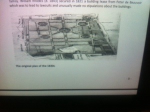
Development was stimulated by the cutting of the Regent’s canal south of Balmes House, by which time the house was an asylum and much of its land had been leased to the Rhodes family. William Rhodes (d. 1843) secured in 1821 a building lease from Peter de Beauvoir which was to lead to lawsuits and unusually made no stipulations about the buildings.
Rhodes planned a grid pattern, with four squares on diagonal streets intersecting at an octagon. His paving and lighting Bill of 1823 was abandoned, however, and development was piecemeal and mainly along the fringe, where modest buildings could most easily find tenants: by the canal, along or off Kingsland Road, and in Tottenham Road. A few subleases were made by Rhodes from 1822 and more from 1823, when Richard Benyon de Beauvoir stopped all activity through an injunction. Rhodes was soon allowed to resume work on Kingsland basin but apparently he started no new building before control of all development passed to de Beauvoir in 1834. Subleases were still made by Rhodes, as of houses in Kingsland Road in 1824, in Enfield Road in 1826, and in Tottenham Road in 1825 and 1828.
Most of the land between Kingsland and Hertford roads had been built on by 1834, except immediately north of Englefield Road. To the west there was new building only by the canal, at the corners of Hertford and Downham Roads, perhaps on the eastern side of the later De Beauvoir Square (nos. 1-16 Park Place), and part of Tottenham Road. Balmes House survived between Downham Road and the canal, although threatened by the lines of Whitmore and Frederick (later De Beauvoir) roads. For the land thereafter leased by R. B. de Beauvoir a
more spacious layout was devised, with terraces mainly in short blocks and many semidetached villas; of the projected squares only the southeastern was retained, as De Beauvoir Square, although the diagonals partly survived in Enfield, Stamford, and Ardleigh roads. Progress was hastened by the proximity of depots in Kingsland basin and by loans from the estate to individual builders. In the 1840s subleases were made for most of the remaining houses. Presumably most builders followed their own designs, although the remaining three sides of De Beauvoir Square, begun in 1838 with Thomas Smith as the chief builder, may have been by W. C. Lockner, architect of St. Peter’s church.
The estate was intended to be almost wholly residential, except around the basin and at the south-west corner, where a factory leased from 1823 was apparently the forerunner of that of Thomas Briggs the tentmaker. Public houses were permitted, the Duke of York in Downham Road being leased to a brewing company as early as 1822, and shops were leased in Southgate Road from 1843. Kingsland Road’s west side was commercial south of


